Blog
The Dutch have a saying: “De hemel geeft; wie vangt, die heeft.” (Which translates to Afrikaans as “Die hemel gee; wie vang, dié het.”) While this mainly refers to the wisdom of catching an opportunity whenever it presents itself, it is also true in a very literal sense when it comes to water.

Our water infrastructure continues to deteriorate, and some catchment areas and dams are becoming less effective as rainfall patterns change. An uninterrupted supply of clean tap water is no longer something we can take for granted.
Fortunately Munster has a relatively steady supply of clean rain. Even better: this rain is of high quality! There are no polluting industries or power stations nearby to introduce heavy metals, chemical pollutants or other contaminants that are difficult to remove; most of our rain comes in straight from the ocean. And we get a lot of it:
- One millimetre of rain equals to one litre per square metre;
- Munster receives, on average, over 100mm of rain per month;
- The average measurement for a three bedroom house is 120 to 140 square metres.
That means that every month an average of about 12,000 litres of good quality rain water land on the roof of even a relatively sensibly sized house — absolutely free!


Of course not every drop of that water can be captured. Very light rain will only wet the roof and not much of it will run down into the gutters and downpipes before the rain stops and the water evaporates. Trees may overhang parts of the roof, or you may not be able to use the entire roof for practical reasons. But even if one budgets on capturing no more than half of the rain water landing on the roof, the total amount available is still well worth it!
There are different approaches to making the most of this free water supply, depending on one’s needs and budget. The most basic option consists of a water tank, a pump and some simple plumbing hardware. All that is required is to place the tank at a convenient location and divert the downpipe from the gutter into it.
The “Cheap & Cheerful” Option
This is a minimal system that merely captures the run-off from the gutters. The water is unpurified and not suitable for drinking, bathing or washing. However, in the average mid-income South African household 30–40% of the entire tap water consumption is used to flush toilets. But we don’t need purified water to flush the loo; any reasonably clean water will do.
The water coming out of this basic system is more than good enough to flush the toilet, which will reduce your tap water consumption by one third. Yes, it’s that simple! The water will be reasonably clear: any sediment coming out of the gutter will end up at the bottom of the tank and only the very small particles in suspension will make it into the cistern. Both the tank and cistern should be cleaned periodically (the tank typically once a year; the cistern every one to two months) but that is all.

Of course such a minimal system does have its limitations. Dust and sand will wash off the roof and into the tank, and some dead leaves, twigs, bugs and other organic matter will also end up in the water and start to decompose there. Fortunately some basic and inexpensive measures will eliminate most of this.
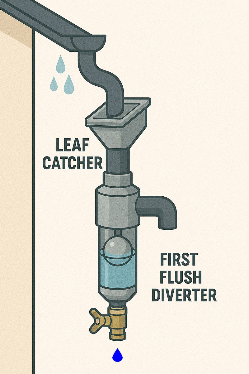
Install a Leaf Catcher
A leaf catcher is a simple screened funnel that keeps leaves, twigs, most bugs and other matter out of the water that goes into the tank. It is inexpensive, easy to install, and will keep a lot of contaminants out of the water. Most of the captured debris will slide off the screen all by itself sooner or later; cleaning the screen is something that typically won’t need to be done more than once every two months or so.

Install a First Flush Diverter
A First Flush Diverter is a vertical tube (typically somewhat wider than a standard downpipe) that is installed between the pipe coming from the leaf cathcer and the pipe going into the tank. The bottom of the pipe is closed with a valve, and inside the pipe is a spherical float.

Initially the vertical pipe is empty. When the rain starts the first run-off (the “first flush”) that comes from the roof washes away most of the dust, sand and other contaminants that have accumulated there (and which are too small to be captured by a leaf catcher) runs into the pipe. As the pipe fills up, the float rises. Eventually when the pipe is full the float reaches the top and closes the inlet of the pipe. Any subsequent rain water will now flow past the closed inlet and into the tank.
The size of the pipe should be large enough so that by the time it is full most sand and dust will have been washed off the roof. This depends on roof size and local conditions.
Once the rain stops the valve at the bottom is opened to drain away the dirty water, and the system is ready for the next rain. Alternatively the valve can be opened just a crack (a “weep hole”) so that the pipe slowly drains between showers. However this leaves the risk of the dirt clogging the small opening.
Water Purification
Water coming out of the tank will generally be as clear as the municipal tap water that we are used to. Any solids will settle to the bottom of the tank and only tiny particles will remain suspended in the water (much like the tap water produced by the industrial purification process used in municipal waterworks). However, the water will not not microbially safe and will be unsuitable for drinking. It may also smell a bit musty, as a result of organic breakdown products that may occur in the water.
The simplest and cheapest way to combat microbes in the water and make it safe to drink is chlorination. This is what the municipal water works do after removing all solid contaminants from the water. There are special water purification tablets to add to water tanks, which are “fizzy” so they spread the chlorine through the water quickly and after 15 minutes the water will be safe to drink. However, these tablets are rather expensive and may be hard to find. They also have a disadvantage: the chlorine compound they contain is sodium-based, which may a problem for people who are on a low-sodium diet. Furthermore, the chlorine will evaporate over time, and another tablet will have to be added to the tank periodically.
As a more cost-effective alternative, HTH makes a type of chlorine tablets that are marketed as being intended for drinking water purification. The chlorine compound in these tables is based on calcium rather than sodium, which eliminates sodium-related health concerns. These tablets are not fizzy and must be used in a refillable pool floater that sits inside the tank and releases the chlorine gradually. This makes the chlorine level in the tank difficult to control: it tends to be either too high or too low. Also, refilling the pool floater periodically is cumbersome. However, when one is on a limited budget and doesn’t mean putting a ladder against the tank once a week to check and adjust the amount of dry chlorine in the floater, this will make the water safe to drink, as well as suitable for showering, washing, dish-washing and all other normal household uses.
Regular bleach or pool chlorine can be used on an occasional basis or in an emergency. This is safe enough in a pinch, but these products are also sodium based and are not food grade, so they are not recommended for regular use.
While chlorine alone makes the water safe to use, there may still be organic breakdown products from moss, leaves, algae etc. present in it, which results in a slight musty smell and flavour. These can be removed by filtration. The simplest way to do this is an under-the-counter filter system consisting of two filters with replaceable filter cartridges. The first filter is typically a 5 or 10 micron particle filter made from plastic (known as a “Melted Spray” or “Spray Blown” filter. (Do not use paper filter cartridges; these are not intended for this application.) The second filter is typically an active carbon filter that not only removes the musty smell and flavour from the water, but also most or all of the chlorine. Active carbon filters come in two forms: Granulated Active Carbon (GAC) cartridges and Carbon Block cartridges. The latter is the best option since the granules have been fused into a porous block. They are slightly more expensive but significantly more effective.
A simple filtration system like this will produce excellent drinking water from the rain water collected in the harvesting tank. The service life of the filter cartridges depends on the quality of the water and the amount of water used, so this is hard to predict, but on average one can expect two to three months between cartridge replacements. If the water coming out of the tank is so cloudy that it will quickly saturate the filter, an inexpensive stainless steel 30 micron mesh filter can be fitted before the under-the-counter filter. These mesh filters have to be cleaned periodically, but they are almost infinitely reusable and don’t have a cartridge that needs to be replaced periodically.

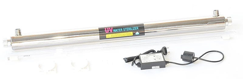
Unfortunately chlorination presents a bit of a problem here: while it does eliminate all microbes, it also significantly reduces the service life of the active carbon filter, since the active carbon absorbs the chlorine along with all the other unwanted smells and flavours. A better (but more expensive) alternative to using chlorine is a water sterilization unit that uses ultraviolet (UV) light. These come in two forms: a UV light that is placed inside the water tank, or an in-line system that is inserted into the water pipe so that water flows through it. The costs of both systems are about the same, although there can be significant differences in price between various brands and suppliers. However, if you have more than one tank (or add one later) each tank must have its own UV light, so with more than one tank an in-line system is the cheaper option. In both cases a typical UV lights uses about 55 watts, which adds up to a significant energy consumption since the light must be on 24/7. (If you have solar power this will be far less of a consideration, of course.) The service life of the UV globe (which is typically a tube rather than a globe) is about a year, so one must factor in the annual replacement costs. However, UV sterilization eliminates the cost (and hassle) of regular chlorine additions to the tank, and it can easily double or triple the service life of Active Carbon filter cartridges, which makes it affordable to filter and sterilize all the water that comes into the house and ensures that the water used for showering, cooking, washing dishes and clothes etc. is of perfect quality.


Practical Considerations
The first question many will ask is whether or not it is possible to stop using municipal water altogether. It may be, but there are a few things to keep in mind. Firstly, the size of the household and the amount of water consumed will be a factor, as well as the amount of space and budget available for tanks. Secondly, while Munster may receive an average of about 100mm of rain per month (see above) this is an average. There will be rainy months (more than 300mm in January to April is typical) and dry months (June to August) with only a little rain or none at all. Being able to get through the dry season requires that the tanks can store at least three months of water and preferably more. There are also wet years and dry years, especially with climate change and the El Niño phenomenon affecting rainfall patterns. Without municipal water as a backup the cost of tanker water can quickly escalate during a long dry spell.
Then there is the cost of installation and maintenance. Most people will want to use a contractor to install a rainwater harvesting system. Unfortunately the Great South African Contractor (a common species found in bakkies throughout the country) comes in many varieties, not all of which are perfect for the job since there are many skills required here.
- Capacity planning:
The most economic tank size is 5000 litres. A tank half that size will cost more than half as much; a tank twice that size will cost more than twice as much. However, one tank will often overflow during a good downpour and then run dry a week or two later, depending on typical water usage. So one can’t really have enough tank space to capture as much as possible during the wet season and get as far as possible through the dry season.. On the other hand, over-investing in too many tanks is just a waste of money, keeping in mind that more tanks also require more space, more plumbing and more maintenance. - Building:
tanks have to be placed on a strong, stable and level foundation. All tanks must be on the same level, and a full 5000 litre water tank weighs more than two double-cab bakkies so the foundation must be able to support that weight. - Wiring/plumbing:
The installation involves considerable amounts of plumbing, which has to be done properly in order to avoid domestic disasters. The wiring must be 100% safe. especially given the combination of electricity and water. - Filtration:
The finer points of water filtration and purification often fall well outside the expertise of the average contractor. - Maintenance:
The placement of the tanks and which portion of the roof they receive their water from may have significant effects of the amount of contaminants that end up in the tank. The tanks will have to be cleaned out periodically, but whether this is required once every few months or once every year (or two) entirely depends on the orientation of the building and the situation around it.
Another issue that requires careful thought is when, how or even if the capital outlay for a rainwater harvesting system will pay for itself. Depending on the household, typical water consumption, available space and budget the optimum balance between capital outlay and municipal water savings must be worked out. However, saving money is not always the point here. There are other important considerations as well:
- Better water quality:
Water purification plants remove only common contaminants, but not the heavy metals, pesticides and chemical pollutants that are to some extent present in the raw water from sources upstream of the catchment areas, dams and rivers from which the water is drawn. The rain water that enters our area straight from the ocean is of a much better quality even before filtration and purification. - Not being dependent municipal water:
Municipal water plants have become increasingly unreliable over the years. By now we have become accustomed to having municipal water available only one day a week, if we are even that lucky. Having one or two backup water tanks is no longer optional these days, but even having the tanks periodically refilled from the municipal supply is by no means guaranteed.

- Not having contamination from failing water infrastructures:
Due to a lack of planning, lack of maintenance, mismanagement, crime and incompetence our water distribution network has fallen apart and is curretnly being held together with sticky tape and paper clips. This often leads to mud rather than water coming out of our taps. - Not paying for air:
Our water meters contain a small paddle wheel that spins when water flows through the meter. Unfortunately this system is designed to measure the flow of water, not air. In air the wheel spins much faster, and after every water outage there is a lot of air in the pipes that has to be blown out through the meter before water can be delivered again. As a result, impossibly high water bills have become common without any actual water being delivered. Challenging this overcharging can be, well, challenging, and the municipality typically places the burden of proof on the consumer. - Sustainability:
Water drawn from dams, rivers and catchment areas has an environmental impact, as does the need to process that water in a municipal water plant. While rainwater harvesting is also not 100% free of environmental effects (tanks, pumps and other components have to be manufactured, transported and eventually recycled, and pumps and UV sterilizers use energy) the environmental balance of rainwater harvesting is a lot more positive than municipal water consumption.
In short, there are a lot of reasons to harvest rainwater, and few reasons not to do it. Depending on your individual situation, options and budget it is possible to start with a small installation and gradually add to it, provided that one plans for future extensions (e.g. when pouring the slab for the tanks’ foundation). If one has the proper skills this can also be a great DIY project, in part or in whole, which helps to save a bundle.